
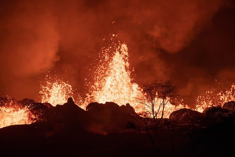
A recent article in the New York Times delves into the impact of the Kīlauea volcanic eruption of 2018 and subsequent efforts to minimize the destruction, which is the hallmark of every such natural disaster. In When Kilauea Erupted, a New Volcanic Playbook Was Written, author, Robin George Andrews, explores the efforts this eruption sparked so that we as a nation may be better prepared for any future large events that this, or other communities in the U.S. may be susceptible to. Measuring areas of seismic activity is key to better understanding how future volcanoes may act, including characteristics of their eruption phase and potential duration. Such knowledge can help inform key information that scientists can provide to the public during evacuation.
Though it is the youngest volcano on the Island of Hawai‘i, USGS quotes this May 3, 2018 event as the “largest lower East Rift Zone (LERZ) eruption and caldera collapse in at least 200 years…” at that time. And yet, despite centuries since such significant activity, it is important to remain vigilant and to learn as much as we can about volcanic behavior.
The New York Times article sums it up:
“Even on the world’s best instrumented volcano,” said Dr. Hon, referring to Kilauea, “we still don’t really understand it that well.”
And yet, despite having so many dangers and complications to contend with, no one died, and thousands of lives were saved during the 2018 crisis.
— Andrews, Robin George. When Kilauea Erupted, a New Volcanic Playbook Was Written. New York Times. 9 Nov. 2021.

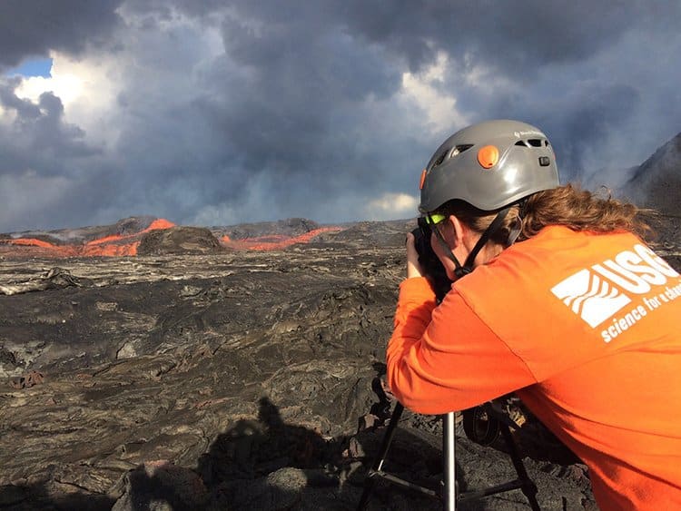
ISTI’s Role in Monitoring
ISTI’s team has decades of experience with the AQMS software used to monitor the earthquakes and other ground-shaking events from this eruption. Six months before the eruption began, ISTI’s experts helped the Hawaiian Volcano Observatory get this software tuned and operational on a Linux platform.
The U.S. Geological Survey continues to bolster its efforts with enhancements and additions to its monitoring network, state-of-the-art equipment, and software, such as ISTI offers, which can only help prepare scientists to understand volcanic behavior better and potentially lessen the impact on our wildlife, businesses, and neighborhoods nationwide.
Related Articles
Read more about AQMS, the software that was used to monitor Kīlauea seismic activity.
Want to Learn AQMS?
2022 Winter AQMS Course Online is accepting registrations.
Learn how to run this earthquake monitoring software.
-
Date: 28 February – 4 March (5 days at 4hrs/day)
Carbon capture and sequestration (CCS) is a vital means of reducing greenhouse gas emissions. It may be humankind’s best weapon against climate change.
And, as technology evolves, the CCS market grows.
As of 2020, researchers valued the global CCS market at $4.17 billion. By 2026, they estimate its value will more than double, to $9.42 billion.
Part of this technological evolution concerns CO₂ capture monitoring technology. Monitoring mitigates risks associated with carbon storage, and it makes long-term sequestration feasible.
In this analysis, discover how CCS works, how new technologies are affecting its impact, and how to develop and implement a CCS monitoring and reporting strategy.
What Is Carbon Capture Sequestration (CCS)?
Carbon capture and storage is a set of processes that reduce or prevent greenhouse gas emissions. It separates out CO₂ prior to—or during—fuel-burning processes.
Then, engineers transport and store the separated carbon in a carbon pool.
A carbon pool is typically underwater or underground. The pool sequesters the fluid, keeping it from contaminating the atmosphere. Some CCS projects aim to store carbon in a space where genetically modified plants can transform it.
Currently, most projects store carbon by injecting it into depleted oil and gas wells, saline formations, or unusable coal beds. These are geologic sequestration tactics.
Modes of Carbon Capture
There are two primary modes of carbon capture: pre-combustion and post-combustion. Oxy-fuel capture is a sub-type of pre-combustion capture. Most carbon capture technologies rely on one of three key separation mechanisms:
-
Advanced solvents
-
Sorbents
-
Membranes
Industrial carbon capture systems currently absorb CO₂ compounds with a carbon dioxide scrubber. Scrubbers use amines to absorb CO₂, which makes the device a sorbent.
Pre-Combustion Capture
Pre-combustion capture utilizes a controlled gasification reaction to oxidize fossil fuel. This enables combustion in an oxygen-saturated environment. The gasification reaction chemically decomposes the fuel, which creates syngas.
Engineers then process that syngas through a water-gas shift reactor (WGS). That process converts carbon into CO². It also increases the concentration of both CO₂ and H₂ in the system.
Using a separation technology, engineers divide the CO₂ and H₂. Some processes then use the H² for fuel. Certain advanced turbine systems and NETL fuel cells already utilize H₂ derived from this process.
After processing, developers can store the segregated CO₂, which is already contained.
Post-Combustion Capture
The best applications of post-combustion capture methods are natural gas and pulverized coal (PC) power plants.
The exhaust produced by these power generation methods is a gaseous waste. Specifically, it’s a mixture of N₂ and CO₂. Post-combustion capture methods separate the CO₂ from this gas stream before it enters the atmosphere.
Today, most post-combustion capture utilizes chemical solvents with amines. Chemical looping combustion is another proposed post-combustion capture technology. Foundations have launched projects researching this technology.
Carbon Dioxide Removal (CDR)
Scientists are currently researching and developing carbon dioxide removal (CDR) strategies. These techniques can remove CO₂ from the atmosphere after it has already been released.
One technology in development is direct air capture (DAC). DAC uses sorbent filters to bind with CO₂ molecules, pulling them out of the air. Or, it may use liquid solution filters.
Once the carbon is captured, engineers plan to store and sequester it. No matter how the carbon is captured, storage methods are similar.
How Does Carbon Capturing or Sequestering Work?
CCS can be divided into two distinct processes: capturing and storage.
Carbon capture technologies are means of separating carbon from the gas or liquid it’s mixed with. Once separated, the carbon is contained for transport and storage.
Carbon capture storage technologies enable engineers to inject carbon deep underground or store it safely in a biologic process.
For an overview of contemporary separation technologies, read “Carbon Capture and Storage: The Way Forward.” Researchers published this 2018 report in the journal Energy & Environmental Science.
It offers a clear breakdown of contemporary carbon separation methods.
Sequestration vs. Storage
Carbon capture sequestration (CCS) describes the complete process of separating, transporting, and storing carbon. Carbon capture storage only refers to the last step of this process.
Engineers often use the two terms interchangeably.
CCS Mechanisms
Developers have proposed a wide variety of carbon storage mechanisms and tools. These technologies include:
-
Geo-sequestration
-
Algae/bacterial metabolization
-
Mineral storage (carbonate formation)
Geological sequestration is the most utilized method so far. Engineers pressurize the separated carbon into supercritical fluid (SCF) form. Then, they inject the fluid carbon deep underground.
It’s theoretically safe to store the carbon in coal seams, under saline formations, beneath oil fields, or in basalt formations. In some circumstances, the carbon remains a liquid due to intense pressure.
Why Is Monitoring Critical?
CO₂ capture monitoring is necessary to mitigate risks inherent to carbon storage. International environmental scientists identify four key risks inherent to geo-sequestration. Risks include:
-
Contamination of drinking water
-
Pressure buildup
-
Hydraulic fractures
-
Leakage
To prevent these adverse effects, the United States Environmental Protection Agency (EPA) requires carbon capture companies to monitor storage sites.
Monitoring must include tracking plume migration. Companies also need to observe:
-
The pressure inside and above the storage reservoir
-
Induced seismicity
-
Secondary trapping mechanism extension
-
Chemistry of local freshwater aquifers
EPA: Greenhouse Gas Reporting Program (GHGRP)
In the United States, carbon storage companies must report the monitoring data through the EPA’s Greenhouse Gas Reporting Program (GHGRP).
The GHGRP tracks emissions from large sources, including industrial facilities and fuel and gas suppliers. Each October, the EPA compiles the data it gathered and publishes it in a public document.
Monitoring, Verification, Accounting (MVA)
The national Carbon Storage Program supports monitoring, verification, accounting, and assessment research.
This systematic approach helps organizations determine the parameters for safe carbon storage across many variables. With these parameters knowns, engineers can develop better tools to strengthen our carbon storage capacity.
These tools will then make carbon storage more accessible and less expensive as technology evolves. Ultimately, information gleaned through monitoring serves the DOE’s Carbon Storage R&D program.
CO₂ Capture Monitoring: Overview
As of 2022, MVA has catalyzed the development of four categories of monitoring tools. The categories are:
-
Subsurface monitoring
-
Tracer (near-surface) monitoring
-
Surface and atmospheric monitoring
-
Intelligent monitoring system (IMS) networks
Seismic monitoring is an indirect, subsurface monitoring method. Recent analyses note that remote monitoring tools have proven successful for many carbon storage sites.
Carbon Capture Seismicity Monitoring
Injection-induced seismicity is a risk inherent to underground carbon sequestration. Injecting carbon can trigger a chain reaction that causes faults to rupture.
Monitoring mitigates the risk of induced seismicity. It also alerts teams to any seismic activity for protection.